Interactive World Maps 2.4.14
Recently Updated
100% Original Product & Well Documented
♥ Loved by Many!
0 sales
Version 2.4.14

GPL License
Original price was: $29.00.$3.99Current price is: $3.99.
- Verified from VirusTotal
- 100% Original Product and Virus Free.
- Free New Version Lifetime On Single Purchase.
- Unlimited Website Usage
- Price is in US dollars and included tax
Sale will end soon

SSL Secured Checkout


Verified From
![]()
![]()
- Products Are Purchased and Downloaded From Original Authors.
- The File is 100% Completely Untouched and Unmodified.
- Last Update: 25.July.2025
- Version: 2.4.14

Premium Membership
Download this product for FREE and also gain access to 5,000+ premium themes and plugins.

Secure Transaction
Your transaction is secure with the Stripe. One of the famous payment gateway
Virus Free
Our all items on our website are Virus free and tested with "McAfee Secure"
Timely Update
After publishing the new update from author we upload the latest file on our website
Product Description and Reviews
Interactive World Maps Latest Version
This is a GPL-distributed version. No official support. Clean, secure, and legally redistributed under the GPL license.
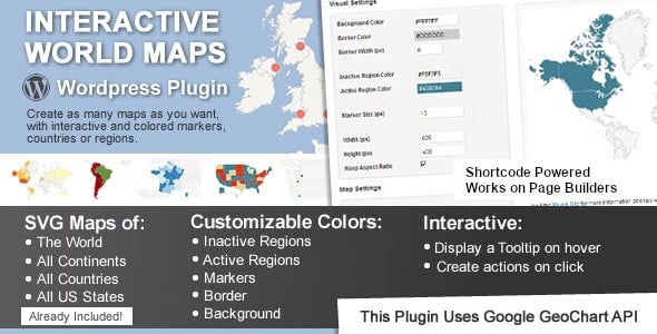
This is a WordPress plugin to create as many maps as you want, with interactive and colored markers, continents, countries, or regions.
Show Different Regions
You will be able to show hundreds of different kinds of maps, already included:
- A map of the entire world.
- A continent or a sub-continent. (Africa, Europe, Americas, Asia, Oceania and all their sub-continents)
- A country. (virtually all the countries in the world are included, featuring the most requested: USA, United Kingdom, Canada, France, Germany, Spain, Italy, Brazil, India, Australia…)
- A country is divided by its regions. *
- A state in the United States.
- The United States is divided by metropolitan areas.
- A state in the United States is divided by metropolitan areas.
Color Regions or add Markers
You can add active colored regions to the map, and display them in 2 different ways:
- As Regions – It will color the whole region, for example, a continent, subcontinent, country, country province, or a US state.
- As Markers -It will display a colored bubble in the chosen regions, which can be a city, a state, or a country.
Responsive
If no width is specified it will load with the maximum width available in the container div. For example, it will load and adapt with different sizes for phones/ipads/laptops. However, after loaded it will not change size if you resize the window.
Since version 1.4 the plugin includes an option to make the maps fully Responsive. This will use jQuery to check if the window size changed and will redraw the map with the new available space.
Add a review
Currently, we are not accepting new reviews
Top Selling
Version 4.0.1

Original price was: $400.00.$3.99Current price is: $3.99.
2218 sales
Version 27.2

Original price was: $99.00.$3.99Current price is: $3.99.
820 sales
Version 3.21.1

Original price was: $249.00.$3.99Current price is: $3.99.
572 sales
Version 3.0.110
Original price was: $129.00.$3.99Current price is: $3.99.
533 sales
Version 8.4.1

Original price was: $59.00.$3.99Current price is: $3.99.
478 sales
Version 4.12.5

Original price was: $59.00.$3.99Current price is: $3.99.
370 sales
Version 12.7.5

Original price was: $59.00.$3.99Current price is: $3.99.
248 sales
Version 8.1.4

Original price was: $99.00.$3.99Current price is: $3.99.
245 sales
Related products
Version 2.2.3

Original price was: $49.00.$3.99Current price is: $3.99.
68 sales
Version 2.2.6

Original price was: $10.00.$3.99Current price is: $3.99.
10 sales
Version 28.3.3

Original price was: $59.00.$3.99Current price is: $3.99.
116 sales
Version 12.4.1.2
Original price was: $160.00.$3.99Current price is: $3.99.
59 sales
Version 2.3.0
Original price was: $15.00.$3.99Current price is: $3.99.
12 sales
Version 2.5.14

Original price was: $59.00.$3.99Current price is: $3.99.
6 sales
Version 4.20.0
Original price was: $99.00.$3.99Current price is: $3.99.
13 sales
Version 4.5.2

Original price was: $49.00.$3.99Current price is: $3.99.
13 sales
Version 3.21.1
Original price was: $249.00.$3.99Current price is: $3.99.
572 sales
Version 2.1.0

Original price was: $22.00.$3.99Current price is: $3.99.
6 sales
Version 7.15.1

Original price was: $69.00.$3.99Current price is: $3.99.
157 sales
Version 1.5.10

Original price was: $22.00.$3.99Current price is: $3.99.
6 sales
Version 2.30.0

Original price was: $89.00.$3.99Current price is: $3.99.
15 sales
Version 2.18.0
Original price was: $59.00.$3.99Current price is: $3.99.
9 sales
Version 1.12.15

Original price was: $199.00.$3.99Current price is: $3.99.
27 sales
Version 3.5.16.1

Original price was: $22.00.$3.99Current price is: $3.99.
15 sales
Version 3.41.0
Original price was: $69.00.$3.99Current price is: $3.99.
4 sales
Version 3.23.4

Original price was: $49.00.$3.99Current price is: $3.99.
104 sales
Version 4.14.0

Original price was: $79.00.$3.99Current price is: $3.99.
19 sales
Version 4.12.5
Original price was: $59.00.$3.99Current price is: $3.99.
370 sales
Version 2.3.2.1

Original price was: $22.00.$3.99Current price is: $3.99.
21 sales
Version 1.44.2

Original price was: $169.00.$3.99Current price is: $3.99.
50 sales
Version 4.37.0
Original price was: $69.00.$3.99Current price is: $3.99.
10 sales
Version 2.12.18

Original price was: $57.00.$3.99Current price is: $3.99.
4 sales
Sorry, no reviews match your current selections
WINTER SALE OFFERS • GET 25% OFF ON 1 YEAR & LIFETIME MEMBERSHIP USE COUPON CODE: SPECIALDISCOUNT25 • BUY TWO GPL PRODUCTS AT JUST $6 USE COUPON CODE: BUY2 • GET 25% OFF ON 1 YEAR & LIFETIME MEMBERSHIP USE COUPON CODE: SPECIALDISCOUNT25 • BUY TWO GPL PRODUCTS AT JUST $6 USE COUPON CODE: BUY2 • GET 25% OFF ON 1 YEAR & LIFETIME MEMBERSHIP USE COUPON CODE: SPECIALDISCOUNT25 • BUY TWO GPL PRODUCTS AT JUST $6 USE COUPON CODE: BUY2 • GET 25% OFF ON 1 YEAR & LIFETIME MEMBERSHIP USE COUPON CODE: SPECIALDISCOUNT25 • BUY TWO GPL PRODUCTS AT JUST $6 USE COUPON CODE: BUY2 •


Reviews
There are no reviews yet